
A major flood threat from a Pacific hurricane is sweeping the US

Want to bookmark your favourite articles and stories to read or reference later? Start your Independent Membership today.
Already a member?
Log in
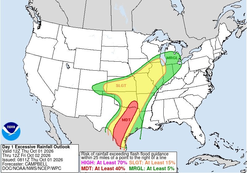
Flooding rain is forecast across the southern and central U.S. through the weekend, with dangerous consequences for travel and flood alerts in place for millions of Americans.
The storms are the remnants of Hurricane Polo, one of 10 hurricanes that have formed during a particularly busy Pacific season and under the influence of a super El Niño climate pattern, according to Ben Knoll, a meteorologist at The Washington Post. The storm sent surf surging along the California coast.
“A broad area including parts of Kansas, Nebraska, Iowa, Illinois and Missouri could see 2 to 4 inches of rain and flooding Wednesday. There’s potential for 4 to 8 inches of rain and flooding in Central Texas into Thursday,” he warned Wednesday.
Several states have already seen impacts from remnants, too.
Two tornadoes spun up in the Texas panhandle, tornadoes ripped across Kansas and floodwaters swept away vehicles this week in Arizona and Nevada.

Flooding also forced evacuations in New Mexico near the Rio Grande. Since then, evacuation orders have been lifted.
And the tropical moisture smashed the all-time single-day rainfall record this week in Lincoln, Nebraska, according to a Thursday post from the National Weather Service.
“Lincoln, NE’s official weather station recorded 6.15 inches of rain, breaking the all-time single-day rainfall record of 5.45 inches set on August 29, 1910,” the agency’s local office said.
The remnants are now traveling on a more easterly path than previously projected, with a risk of excessive rainfall extending as far as the Midwest and Great Lakes.
“In the hardest hit areas, rainfall could exceed a half-foot, equivalent to three to six Septembers’ worth of rain,” Knoll noted.
In response, officials in Wichita, Kansas, advised residents to avoid driving on Thursday due to the threats, according to KWCH. A treatment plant in Des Moines, Iowa, closed giant gates in the levee surrounding its treatment plant on Wednesday, KCCI reported.
But these remnants aren’t the only flooding threat sweeping the nation this week.
A surge of tropical moisture is expected to bring rounds of drenching thunderstorms in the Southeast and Mid-Atlantic by the weekend, starting in Texas, according to forecaster AccuWeather.
“By the weekend, repeated rounds of heavy rain and thunderstorms will overspread areas as far north as the Delmarva Peninsula,” meteorologist Jack Wojczynski wrote Wednesday.
Between 1-3 inches of rain is anticipated widely, with higher levels possible in some places.
Further north, in the Northeast, a cold front from Canada will bring rain and a few thunderstorms on Friday – but widespread heavy rainfall is not expected.
